Scholtoi - ein deutsches Dorf im Norden von Bessarabien
Bessarabien ist ein historisches Gebiet in Südosteuropa und liegt im heutigen Moldawien sowie in der Ukraine. Ab Anfang des 19. Jahrhunderts wurde dieses Land auch von deutschen Auswanderern besiedelt. Unter schwierigsten Bedingungen entstanden über 150 Gemeinden.
Im Laufe seiner Geschichte war Bessarabien immer wieder ein begehrtes Streitobjekt. So gehörte Bessarabien bis 1918 zu Russland, dann bis zum Zweiten Weltkrieg zu Rumänien. Durch den Umsiedlungsvertrag des Jahres 1940 zwischen Deutschland und Sowjetrussland kamen mehr als 93000 Bessarabiendeutsche zurück in die Heimat ihrer Vorfahren.
Im Laufe seiner Geschichte war Bessarabien immer wieder ein begehrtes Streitobjekt. So gehörte Bessarabien bis 1918 zu Russland, dann bis zum Zweiten Weltkrieg zu Rumänien. Durch den Umsiedlungsvertrag des Jahres 1940 zwischen Deutschland und Sowjetrussland kamen mehr als 93000 Bessarabiendeutsche zurück in die Heimat ihrer Vorfahren.
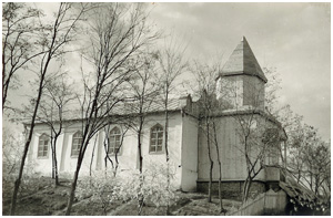 Die Kirche der Deutschen von Scholtoi. Sie existiert leider nicht mehr. |
Nach neueren Erkenntnissen aus Kirchenbüchern wurde Scholtoi bereits 1864 gegründet. Das Dorf liegt etwa 100 km Luftlinie von Moldawiens Hauptstadt Kischinew entfernt im Südosten der Stadt Falesti. Die Siedler waren deutsche Kolonisten, die aus Galizien nach Bessarabien kamen, aber auch Deutsche aus anderen sich auflösenden älteren Gemeinden im nördlichen Bessarabien. Aufgrund der großen Armut der meisten Einwohner wanderten einige Familien im ersten Viertel des 20. Jahrhunderts nach Kanada und Brasilien aus. Zum Zeitpunkt der Umsiedlung am 2. Oktober 1940 lebten in Scholtoi etwa 300 Einwohner in 57 Bauernhöfen. Heute heißt der Ort Şoltoaia (russisch: Шолтоая, früher Шолтой). Andere deutsche Dörfer im Norden von Bessarabien waren Naslawtscha, Staftschani, Alt- und Neu-Sarata (nicht zu verwechseln mit den gleichnamigen Orten im Süden von Bessarabien), Kodiasy (Gudias), Neu-Strymba, Ryschkanowka und Glückstal. |